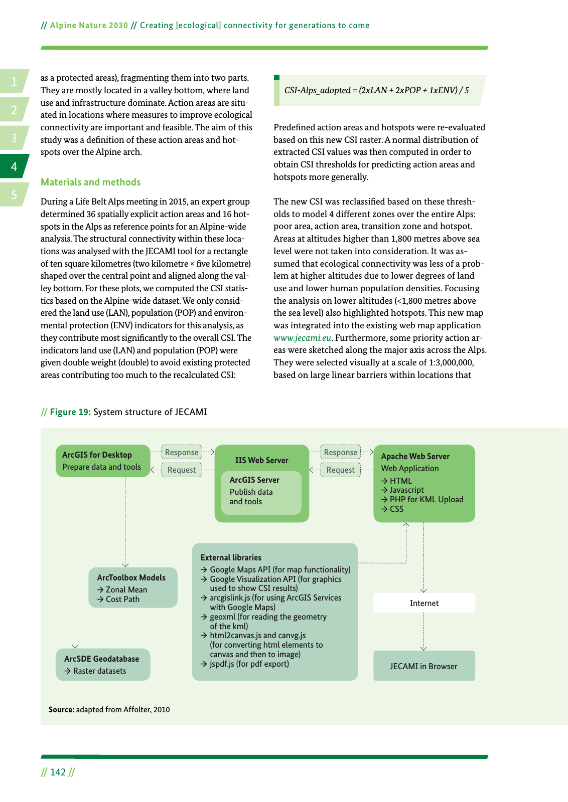
14 2 5 3 Alpine Nature 2030 Creating ecological connectivity for generations to come 142 Figure 19 System structure of JECAMI as a protected areas fragmenting them into two parts They are mostly located in a valley bottom where land use and infrastructure dominate Action areas are situ ated in locations where measures to improve ecological connectivity are important and feasible The aim of this study was a de nition of these action areas and hot spots over the Alpine arch Materials and methods During a Life Belt Alps meeting in 2015 an expert group determined 36 spatially explicit action areas and 16 hot spots in the Alps as reference points for an Alpine wide analysis The structural connectivity within these loca tions was analysed with the JECAMI tool for a rectangle of ten square kilometres two kilometre ve kilometre shaped over the central point and aligned along the val ley bottom For these plots we computed the CSI statis tics based on the Alpine wide dataset We only consid ered the land use LAN population POP and environ mental protection ENV indicators for this analysis as they contribute most signi cantly to the overall CSI The indicators land use LAN and population POP were given double weight double to avoid existing protected areas contributing too much to the recalculated CSI CSI Alps adopted 2xLAN 2xPOP 1xENV 5 Prede ned action areas and hotspots were re evaluated based on this new CSI raster A normal distribution of extracted CSI values was then computed in order to obtain CSI thresholds for predicting action areas and hotspots more generally The new CSI was reclassi ed based on these thresh olds to model 4 different zones over the entire Alps poor area action area transition zone and hotspot Areas at altitudes higher than 1 800 metres above sea level were not taken into consideration It was as sumed that ecological connectivity was less of a prob lem at higher altitudes due to lower degrees of land use and lower human population densities Focusing the analysis on lower altitudes 1 800 metres above the sea level also highlighted hotspots This new map was integrated into the existing web map application www jecami eu Furthermore some priority action ar eas were sketched along the major axis across the Alps They were selected visually at a scale of 1 3 000 000 based on large linear barriers within locations that Source adapted from Affolter 2010 ArcGIS for Desktop Prepare data and tools IIS Web Server ArcGIS Server Publish data and tools Apache Web Server Web Application HTML Javascript PHP for KML Upload CSS Internet JECAMI in Browser External libraries Google Maps API for map functionality Google Visualization API for graphics used to show CSI results arcgislink js for using ArcGIS Services with Google Maps geoxml for reading the geometry of the kml html2canvas js and canvg js for converting html elements to canvas and then to image jspdf js for pdf export Response Response Request Request ArcSDE Geodatabase Raster datasets ArcToolbox Models Zonal Mean Cost Path
Hinweis: Dies ist eine maschinenlesbare No-Flash Ansicht.
Klicken Sie hier um zur Online-Version zu gelangen.
Klicken Sie hier um zur Online-Version zu gelangen.