Reason Magazine 2014 Quartal 2 Seite 33
Hinweis: Dies ist eine maschinenlesbare No-Flash Ansicht.Klicken Sie hier um zur Online-Version zu gelangen.
Inhalt
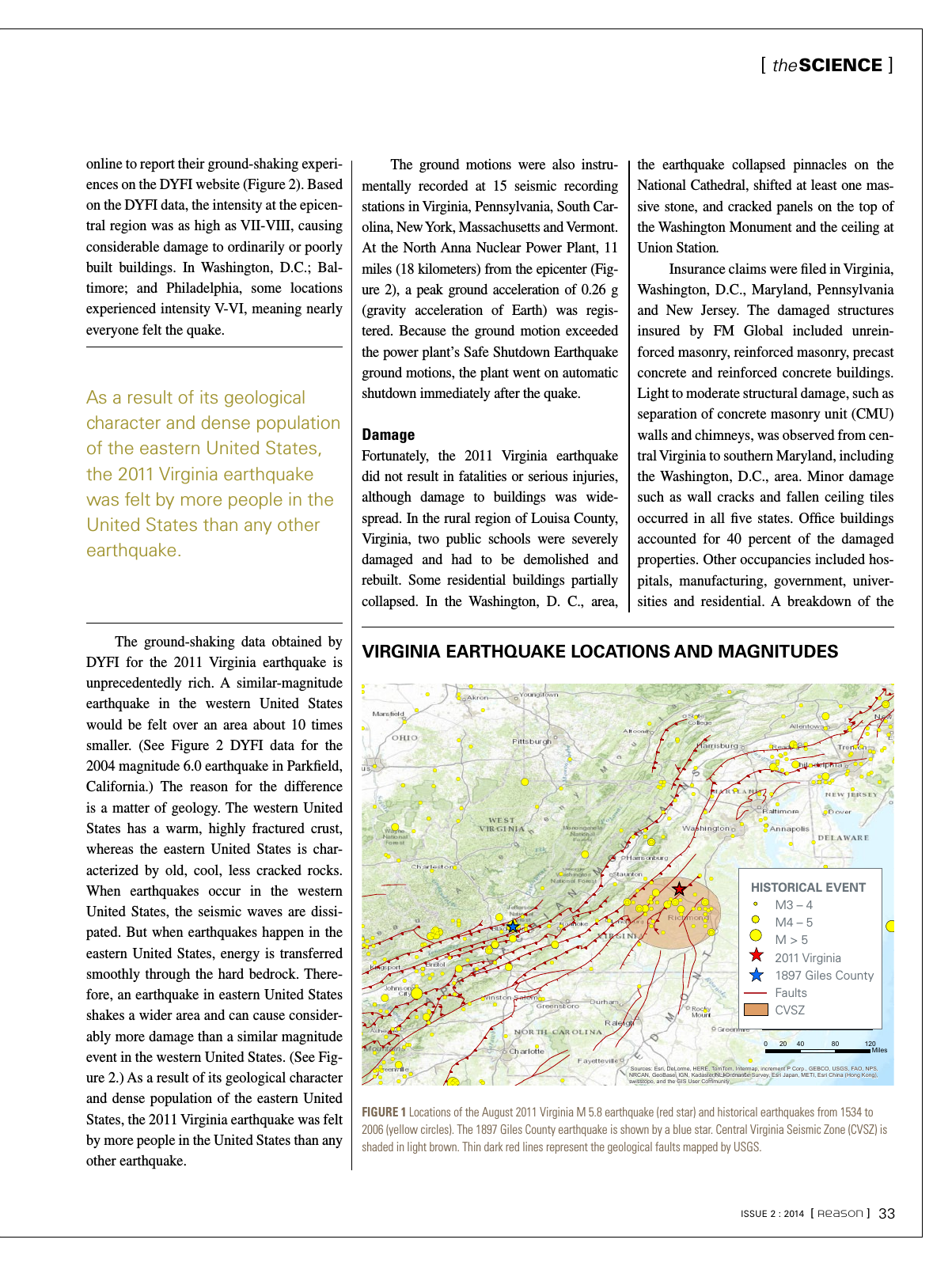
online to report their ground shaking experi ences on the DYFI website Figure 2 Based on the DYFI data the intensity at the epicen tral region was as high as VII VIII causing considerable damage to ordinarily or poorly built buildings In Washington D C Bal timore and Philadelphia some locations experienced intensity V VI meaning nearly everyone felt the quake The ground shaking data obtained by DYFI for the 2011 Virginia earthquake is unprecedentedly rich A similar magnitude earthquake in the western United States would be felt over an area about 10 times smaller See Figure 2 DYFI data for the 2004 magnitude 6 0 earthquake in Parkfield California The reason for the difference is a matter of geology The western United States has a warm highly fractured crust whereas the eastern United States is char acterized by old cool less cracked rocks When earthquakes occur in the western United States the seismic waves are dissi pated But when earthquakes happen in the eastern United States energy is transferred smoothly through the hard bedrock There fore an earthquake in eastern United States shakes a wider area and can cause consider ably more damage than a similar magnitude event in the western United States See Fig ure 2 As a result of its geological character and dense population of the eastern United States the 2011 Virginia earthquake was felt by more people in the United States than any other earthquake VIRGINIA EARTHQUAKE LOCATIONS AND MAGNITUDES FIGURE 1 Locations of the August 2011 Virginia M 5 8 earthquake red star and historical earthquakes from 1534 to 2006 yellow circles The 1897 Giles County earthquake is shown by a blue star Central Virginia Seismic Zone CVSZ is shaded in light brown Thin dark red lines represent the geological faults mapped by USGS The ground motions were also instru mentally recorded at 15 seismic recording stations in Virginia Pennsylvania South Car olina New York Massachusetts and Vermont At the North Anna Nuclear Power Plant 11 miles 18 kilometers from the epicenter Fig ure 2 a peak ground acceleration of 0 26 g gravity acceleration of Earth was regis tered Because the ground motion exceeded the power plant s Safe Shutdown Earthquake ground motions the plant went on automatic shutdown immediately after the quake Damage Fortunately the 2011 Virginia earthquake did not result in fatalities or serious injuries although damage to buildings was wide spread In the rural region of Louisa County Virginia two public schools were severely damaged and had to be demolished and rebuilt Some residential buildings partially collapsed In the Washington D C area the earthquake collapsed pinnacles on the National Cathedral shifted at least one mas sive stone and cracked panels on the top of the Washington Monument and the ceiling at Union Station Insurance claims were filed in Virginia Washington D C Maryland Pennsylvania and New Jersey The damaged structures insured by FM Global included unrein forced masonry reinforced masonry precast concrete and reinforced concrete buildings Light to moderate structural damage such as separation of concrete masonry unit CMU walls and chimneys was observed from cen tral Virginia to southern Maryland including the Washington D C area Minor damage such as wall cracks and fallen ceiling tiles occurred in all five states Office buildings accounted for 40 percent of the damaged properties Other occupancies included hos pitals manufacturing government univer sities and residential A breakdown of the As a result of its geological character and dense population of the eastern United States the 2011 Virginia earthquake was felt by more people in the United States than any other earthquake Sources Esri DeLorme HERE TomTom Intermap increment P Corp GEBCO USGS FAO NPS NRCAN GeoBase IGN Kadaster NL Ordnance Survey Esri Japan METI Esri China Hong Kong swisstopo and the GIS User Community Historical Events M 3 4 M 4 5M 5 2011 Virginia 1897 Giles County FaultsCVSZ 0 40 80 12020 Miles HISTORICAL EVENT M3 4 M4 5 M 5 2011 Virginia 1897 Giles County Faults CVSZ theSCIENCE ISSUE 2 2014 Reason 33